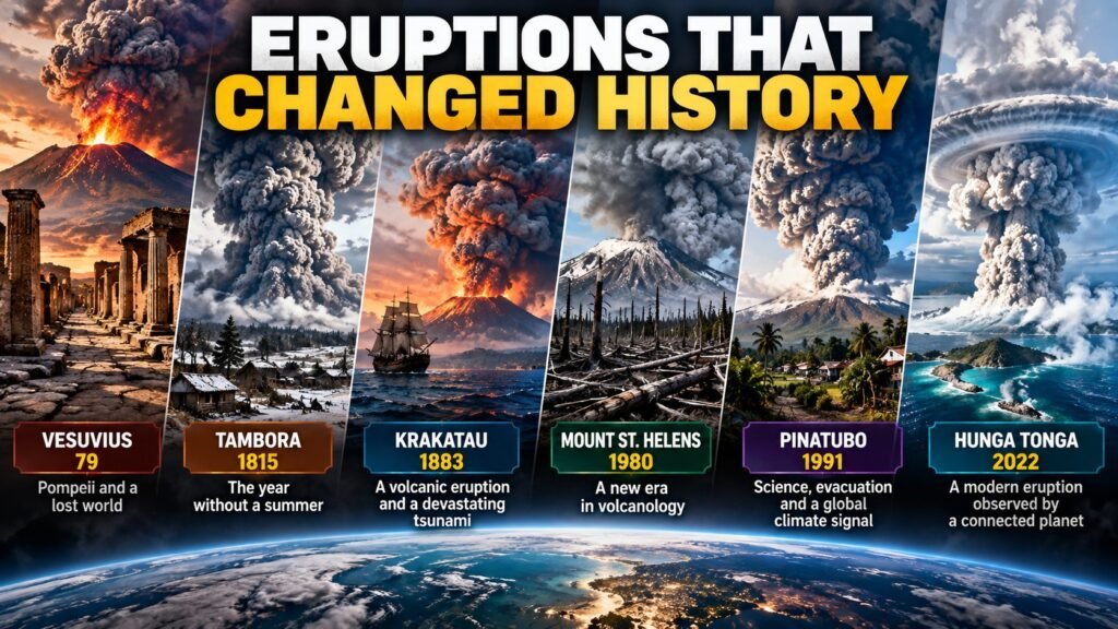
This guide explores volcanic eruptions that changed history, the effects they left behind, and the lessons scientists learned from them.
Major volcanic eruptions do not end when lava stops flowing, ash columns disappear, or explosions finally become quiet.
Some eruptions have destroyed cities. Others have generated tsunamis, temporarily altered global climate, contributed to agricultural crises, or fundamentally changed the way scientists monitor volcanoes.
And history reveals an especially important lesson:
the size of an eruption alone does not determine its human consequences.
The volcano’s location, the population exposed, the hazards produced, atmospheric conditions, and the ability of communities to prepare can turn eruptions of similar magnitude into very different disasters.
These six eruptions help explain how our understanding of volcanoes — and our ability to monitor them — has evolved.
You can also check current volcanic activity and official alerts on EarthSentra.
Volcanic eruptions that changed history: Vesuvius, AD 79
The AD 79 eruption of Mount Vesuvius is one of the best-known volcanic disasters in history.
Pompeii and other communities surrounding the volcano were devastated.
For centuries, Pompeii remained buried beneath volcanic deposits. Paradoxically, the material that destroyed the city also preserved an extraordinary archaeological record of everyday Roman life.
The eruption is also one of history’s most important examples of the dangers associated with explosive volcanism.
USGS classifies the AD 79 Vesuvius eruption as VEI 5 and identifies pyroclastic flows among the major causes of death associated with the disaster.
What Vesuvius Taught Us
Volcanic danger cannot be evaluated simply by considering the distance that lava might travel.
Explosive eruptions can generate towering eruption columns, heavy tephra fall, and fast-moving pyroclastic density currents.
Vesuvius also left another lesson that remains relevant almost two thousand years later:
a volcano surrounded by generations of human settlement is still a volcano that requires monitoring, preparedness, and hazard planning.
Tambora, 1815: When an Eruption Affected the Climate
In April 1815, Mount Tambora in present-day Indonesia produced the largest explosive eruption in recorded history.
The Smithsonian Global Volcanism Program identifies it as the largest historical explosive eruption, and USGS classifies it as VEI 7.
Its consequences were not confined to Indonesia.
Powerful explosive eruptions can inject large quantities of sulfur dioxide high into the atmosphere. There, chemical reactions can produce sulfate aerosols that reflect part of the incoming sunlight and temporarily cool Earth’s surface.
After Tambora, 1816 became known in parts of Europe and North America as the “Year Without a Summer.”
Unusually cold conditions and severe weather anomalies contributed to crop failures and food shortages in several regions.
USGS also lists Tambora among the deadliest volcanic eruptions since 1500, with famine contributing substantially to its overall human impact.
What Tambora Taught Us
A volcanic eruption can become a global event even when most of the world’s population lives thousands of kilometers away.
Tambora also helps explain an important distinction:
volcanic ash itself is not the primary cause of the longer-lasting global cooling associated with major eruptions.
Sulfate aerosols produced from sulfur dioxide reaching the stratosphere play the crucial role.
Krakatau, 1883: The Power of Volcanic Tsunamis
In August 1883, Krakatau produced one of the most famous eruptions of the modern era.
The volcano lies in the Sunda Strait between Java and Sumatra.
The eruption generated ashfall, pyroclastic flows, enormous explosions, and structural collapse.
But much of the human tragedy resulted from another hazard:
tsunamis.
According to the Smithsonian Global Volcanism Program, the 1883 catastrophe caused more than 36,000 deaths, most resulting from tsunamis that struck nearby coastlines of Java and Sumatra.
USGS similarly identifies tsunami activity as the primary cause of death associated with the disaster.
Krakatau itself was physically transformed.
Much of the former volcanic island collapsed. Decades later, a new volcanic cone began emerging inside the caldera:
Anak Krakatau — “Child of Krakatau.”
It remains volcanically active.
What Krakatau Taught Us
Coastal and island volcanoes can generate hazards extending far beyond the eruption site.
The chain can become:
volcano → ocean → tsunami → distant coastline
This is why modern hazard monitoring cannot always treat natural disasters as completely independent phenomena.
Volcanoes, earthquakes, landslides, and tsunamis can interact through chains of events.
That relationship is also one reason EarthSentra brings together information about volcanoes, earthquakes, tsunamis, and other natural hazards within the same monitoring platform.
Mount St. Helens, 1980: A New Era of Modern Volcanology
On May 18, 1980, Mount St. Helens in the United States underwent a dramatic transformation.
After approximately two months of earthquakes, small explosions, and deformation of the volcano, a magnitude 5.1 earthquake was associated with the collapse of its north flank.
The sudden removal of pressure triggered a devastating lateral blast.
The eruption also generated a massive ash column, pyroclastic flows, and lahars that damaged forests, roads, bridges, and buildings.
Fifty-seven people died.
But Mount St. Helens also became an extraordinary natural laboratory.
Scientists were able to study changes in:
- seismic activity;
- ground deformation;
- volcanic emissions;
- lava-dome growth;
- the physical structure of the volcano.
The experience contributed substantially to advances in volcano monitoring, hazard assessment, and scientific communication.
What Mount St. Helens Taught Us
One of the major lessons was that monitoring a single parameter is not enough.
Modern observatories combine multiple disciplines and technologies:
seismology + deformation + gas monitoring + satellites + geology + direct observation
The eruption also changed scientists’ understanding of volcanic flank collapse and lateral explosions.
The experience gained at Mount St. Helens influenced volcano-monitoring practices used around the world.
Pinatubo, 1991: Science, Evacuation and a Global Climate Signal
Mount Pinatubo in the Philippines produced one of the largest eruptions of the twentieth century in June 1991.
Its historical importance is not simply a matter of eruption size.
Pinatubo demonstrated two exceptionally important things:
scientific monitoring can help reduce human losses, and a major volcanic eruption can temporarily affect global climate.
The eruption injected enormous quantities of sulfur dioxide into the stratosphere.
USGS estimates approximately 20 million metric tons of SO₂ were released, eventually producing a widespread sulfate aerosol layer.
These aerosols spread around the planet.
The effect was large enough to produce measurable temporary cooling of Earth’s surface during the following years.
What Pinatubo Taught Us
Pinatubo gave modern scientists an exceptional opportunity to directly observe how a major volcanic eruption interacts with the atmosphere.
Satellites followed the volcanic cloud and aerosols as they spread around the world.
The eruption reinforced something Tambora had demonstrated long before satellites existed:
volcanoes can temporarily influence the global climate system.
However, these effects should not be confused with permanent climate change caused by an individual eruption.
The climatic influence of major historical eruptions generally diminishes within a few years.
Hunga Tonga–Hunga Ha’apai, 2022: An Eruption Observed by a Connected Planet
On January 15, 2022, Hunga Tonga–Hunga Ha’apai produced an extraordinary submarine volcanic eruption in the Pacific.
The Smithsonian Global Volcanism Program classifies the climactic event as VEI 5.
But the eruption attracted worldwide scientific attention because of the extraordinary variety and scale of its effects.
The explosion generated atmospheric waves detected around the globe.
The associated Lamb wave circled Earth multiple times.
The eruption also generated a destructive tsunami.
USGS reported tsunami run-up reaching approximately 20 meters above sea level on some nearby inhabited islands.
What Hunga Tonga Taught Us
Hunga Tonga occurred in a completely different technological era from Tambora or Krakatau.
Satellites, seismic stations, atmospheric sensors, pressure instruments, and observation networks distributed around the world recorded the event almost in real time.
Scientists gained an extraordinary view of how a powerful volcanic explosion can simultaneously interact with:
the atmosphere, the ocean, and the solid Earth.
It also demonstrated once again that a submarine volcano can create consequences crossing the traditional boundaries between different types of natural hazards.
Six Eruptions, Six Different Types of Impact
These eruptions matter not simply because they were large.
Each represents a different historical lesson.
Vesuvius — AD 79
Demonstrated the devastating impact explosive volcanism can have on nearby communities.
Tambora — 1815
Showed that an eruption can temporarily alter global climate and contribute to social consequences thousands of kilometers away.
Krakatau — 1883
Demonstrated the ability of volcanic activity and structural collapse to generate devastating tsunamis.
Mount St. Helens — 1980
Transformed scientific understanding of flank collapse, lateral blasts, and modern volcano monitoring.
Pinatubo — 1991
Allowed scientists to observe a major atmospheric disturbance with modern instruments while demonstrating the importance of monitoring and evacuation planning.
Hunga Tonga — 2022
Showed how modern global networks can observe interactions between volcanoes, the atmosphere, oceans, and tsunamis almost simultaneously.
The Largest Eruption Does Not Always Produce the Worst Disaster
There is an important distinction between hazard and risk.
A massive eruption in a remote region may result in fewer casualties than a smaller eruption close to a vulnerable population.
This means:
eruption magnitude ≠ magnitude of the human disaster
Risk also depends on exposure and vulnerability.
Population density, infrastructure, evacuation routes, monitoring systems, emergency communication, and preparedness can dramatically influence the outcome.
What Does VEI Mean?
Historical eruption comparisons frequently use the abbreviation VEI, meaning Volcanic Explosivity Index.
The scale is used to describe the relative size of explosive eruptions.
It ranges from 0 to 8 and considers characteristics including the amount of material erupted and eruption-column behavior.
However, VEI should not be interpreted as a direct measurement of danger to people.
For example, a lower-VEI eruption can still be catastrophic if it occurs near a densely populated area or generates hazards such as lahars, pyroclastic flows, or tsunamis.
For perspective:
Mount St. Helens 1980 — VEI 5
Vesuvius AD 79 — VEI 5
Krakatau 1883 — VEI 6
Tambora 1815 — VEI 7
VEI describes the eruption.
It does not, by itself, describe the disaster.
From Watching Volcanoes to Monitoring Them Continuously
For most of human history, communities could interpret only what they could see, hear, smell, or feel.
Today, an active volcano may be monitored using:
- seismometers;
- GNSS stations;
- tiltmeters;
- gas sensors;
- cameras;
- radar;
- satellites.
These instruments allow scientists to detect processes invisible to the human eye.
Mount St. Helens played an important role in this transformation.
Modern volcano monitoring increasingly combines earthquake activity, ground deformation, gas emissions, thermal observations, satellite measurements, geological evidence, and other information.
That does not mean scientists can predict the exact time and size of every eruption.
It means they have far more tools for detecting changes, developing possible scenarios, and communicating hazards.
The Connection Between Volcanoes and Other Disasters
The historical examples also demonstrate why natural hazards cannot always be understood independently.
Krakatau and Hunga Tonga generated tsunamis.
Volcanic earthquakes can accompany magma movement.
Flank collapses can trigger landslides.
Heavy rain mixing with volcanic deposits can generate lahars.
Large explosive eruptions can inject gases into the stratosphere and temporarily affect climate.
This creates a broader system of interacting hazards rather than a collection of completely isolated events.
EarthSentra was designed around this idea: bringing different natural hazards together so users can follow the wider situation rather than looking at each phenomenon in isolation.
You can explore EarthSentra’s global natural-hazard monitoring portal.
The Biggest Lesson: Information Before the Emergency
Historical eruptions reveal an extraordinary technological progression.
In AD 79, there was no volcano observatory transmitting real-time information about Vesuvius.
In 1815, there were no satellites capable of tracking Tambora’s atmospheric effects.
In 1883, there was no modern global tsunami warning network.
In 1980, Mount St. Helens helped transform modern volcanology.
In 1991, Pinatubo was observed using modern instruments and satellites.
And in 2022, Hunga Tonga was recorded almost simultaneously by sensors distributed across the planet.
Technology has changed enormously.
But one fundamental principle remains:
understanding the hazard before the emergency can save lives.
EarthSentra brings together current volcanic activity and available official alert information to make that information easier to follow.
Evacuation orders and emergency instructions, however, always come from the responsible authorities.
These historical lessons also help explain the importance of modern monitoring systems. Our guide to volcano alert levels and their meaning in different countries explains how agencies communicate a volcano’s status.
Frequently Asked Questions
What was the largest volcanic eruption in recorded history?
The 1815 eruption of Mount Tambora is generally regarded as the largest explosive eruption in recorded history and is classified as VEI 7.
Which volcanic eruption caused the “Year Without a Summer”?
The 1815 Tambora eruption contributed to atmospheric conditions associated with unusually cold weather in 1816, remembered in parts of the Northern Hemisphere as the “Year Without a Summer.”
Can a volcanic eruption cause a tsunami?
Yes. Krakatau in 1883 and Hunga Tonga in 2022 are major historical examples of volcanic events associated with destructive tsunamis.
Can volcanoes change the climate?
Major explosive eruptions that inject sufficient sulfur dioxide into the stratosphere can cause temporary global cooling through the formation of sulfate aerosols.
The effects of individual historical eruptions generally last years rather than representing permanent climate change on their own.
Is a VEI 7 eruption automatically more dangerous than a VEI 6 eruption?
Not necessarily.
VEI primarily describes eruption size and explosivity, not the direct risk to a population.
Risk also depends on the hazards produced, population exposure, vulnerability, geography, and preparedness.
Where can I check current volcanic activity?
You can check Volcanoes Today on EarthSentra for current volcanic activity and available official alert information.
Sources
U.S. Geological Survey (USGS): Volcanoes Can Affect Climate; Mount St. Helens: The 1980 Eruption Changed the Future of Volcanology.
Smithsonian Institution — Global Volcanism Program: Tambora, Krakatau and Hunga Tonga–Hunga Ha’apai.