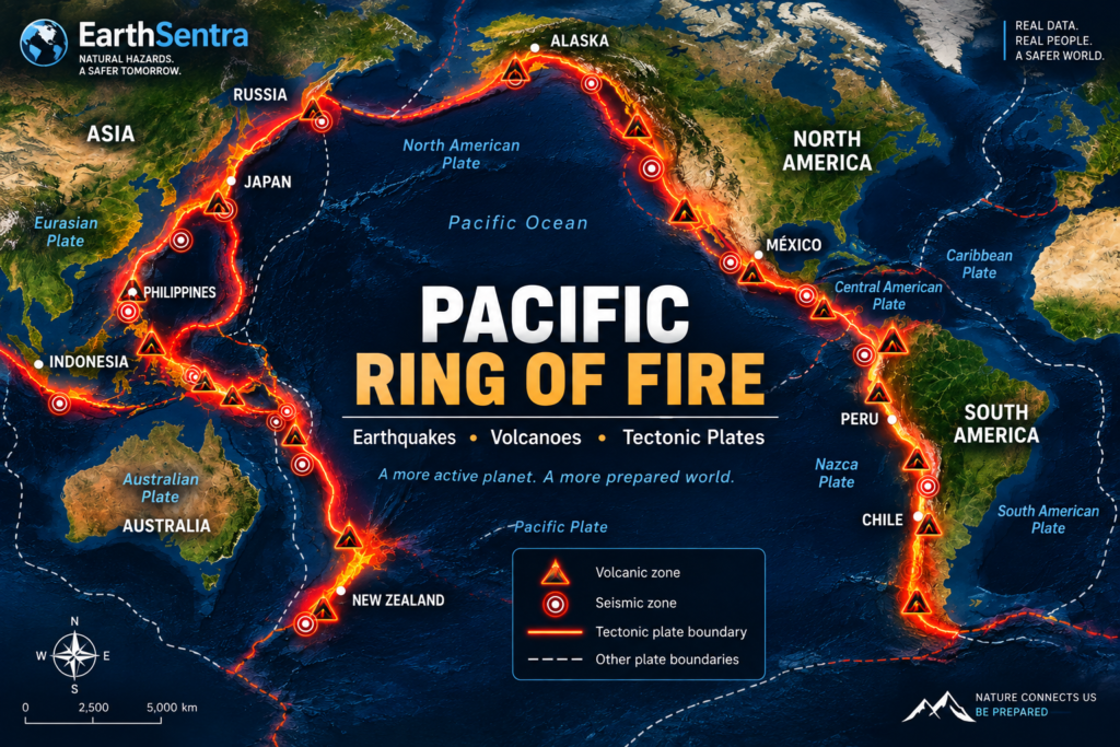
Earthquakes and volcanoes in Japan are closely linked to the country’s position in the Pacific Ring of Fire and the interaction of tectonic plates.
Japan is one of the most geologically active regions on Earth. Frequent earthquakes, active volcanoes, and a long history of tsunamis are closely connected to the country’s location within a complex zone of interacting tectonic plates around the Pacific Ocean.
The Japanese archipelago lies within the broader region popularly known as the Pacific Ring of Fire, where many of the world’s major seismic and volcanic zones are concentrated.
This geological setting explains why earthquakes are a regular part of life in Japan, why the country has numerous active volcanoes, and why Japan has developed some of the world’s most extensive natural-hazard monitoring systems.
For current information, you can check the latest earthquakes in Japan on EarthSentra.
Earthquakes and volcanoes in Japan: the Pacific Ring of Fire
Japan lies along the western edge of the Pacific Ocean in a region where several tectonic plates interact.
This broader seismic and volcanic region is commonly known as the Pacific Ring of Fire.
The concentration of plate boundaries around the Pacific produces major subduction zones, deep ocean trenches, volcanic arcs, and intense seismic activity.
Japan is one of the clearest examples of the relationship between plate tectonics, earthquakes, and volcanoes.
However, the Ring of Fire is not a single geological structure capable of “activating” all at once. It consists of many different tectonic systems that must be studied individually.
The Tectonic Plates Around Japan
Japan is often described as being located near the convergence of four major tectonic plates: the Pacific Plate, the Philippine Sea Plate, and continental-side blocks traditionally associated with the Eurasian and North American plates.
The actual geology is more complex, and scientific models may divide these regions into smaller tectonic blocks.
The essential point for understanding Japan’s seismic activity is that two major oceanic plates are being forced beneath plates on the continental side of Japan.
The Pacific Plate subducts beneath the region from the east, while the Philippine Sea Plate participates in subduction farther south.
This movement continues slowly over years, decades, centuries, and geological timescales.
But the plates do not always move smoothly.
Sections of a plate boundary can become partially locked while tectonic motion continues. Stress accumulates until the rocks eventually slip and release stored energy.
An earthquake occurs.
Why Japan Experiences So Many Earthquakes
Japan experiences frequent earthquakes because it lies beside some of the most active tectonic plate boundaries on Earth.
Not all Japanese earthquakes have the same origin.
Some occur along the boundaries between tectonic plates. Others occur within the subducting plates themselves.
Japan also experiences shallow earthquakes associated with active faults within the islands.
As a result, earthquakes can occur at different depths and in many different parts of the country.
A small earthquake does not necessarily mean that a larger earthquake will follow. Seismic sequences must be evaluated using observations from the specific region and event.
EarthSentra allows you to follow current seismic activity in Japan, including available information about magnitude, depth, location, and time.
Japan’s Major Subduction Zones
Subduction zones are fundamental to understanding Japan’s largest earthquakes.
Subduction occurs when one tectonic plate is forced beneath another and descends into Earth’s interior.
Important trenches and tectonic systems around Japan include the Japan Trench and the Nankai Trough.
These regions are capable of accumulating enormous amounts of tectonic stress.
When a large section of a locked plate boundary suddenly slips, a major earthquake can occur.
Large subduction earthquakes are also particularly important for tsunami risk when they produce significant displacement of the seafloor.
Earthquakes and Tsunamis in Japan
Japan’s history of tsunamis is closely related to its tectonic environment.
When certain undersea earthquakes significantly displace the ocean floor vertically, the water above it can also be displaced.
That disturbance can propagate across the ocean as a tsunami.
However, not every earthquake generates a tsunami.
Tsunami generation depends on several factors, including magnitude, depth, location, fault geometry, and the amount and direction of seafloor displacement.
An earthquake occurring offshore from Japan therefore does not automatically mean that a tsunami warning is in effect.
The Japan Meteorological Agency (JMA) is responsible for evaluating tsunami hazards and issuing official tsunami information in Japan.
You can check current tsunami information for Japan on EarthSentra.
The 2011 Tōhoku Earthquake and Tsunami
On March 11, 2011, one of the most significant natural disasters in modern Japanese history occurred off the coast of the Tōhoku region.
The Great East Japan Earthquake reached approximately magnitude 9 and involved a massive rupture along the subduction zone off northeastern Japan.
The earthquake generated a devastating tsunami that affected extensive areas along Japan’s Pacific coast.
The 2011 disaster demonstrated the enormous amount of energy that can be released along Japan’s subduction zones.
It also had a profound effect on disaster monitoring, preparedness, coastal protection, and emergency communication in Japan.
You can explore current and historical context through EarthSentra’s earthquake information for Japan.
Volcanic Activity in Japan
The same regional tectonic processes associated with frequent earthquakes also play an important role in the formation of volcanoes.
At subduction zones, descending oceanic plates carry materials into Earth’s interior. The resulting physical and chemical processes contribute to magma generation.
Some of this magma can rise through the crust and feed volcanic systems.
Over millions of years, these processes create extensive volcanic arcs.
The Japan Meteorological Agency classifies 111 volcanoes in Japan as active.
This does not mean that all 111 volcanoes are erupting.
An “active volcano” is a geological classification and should not be confused with a current volcanic alert or an ongoing eruption.
This distinction is essential when interpreting volcanic information.
EarthSentra separates these concepts through its current volcanic activity information: geological classification, observed activity, official alert level, and a confirmed eruption are not the same thing.
Japan’s Volcanoes
Volcanoes are distributed across much of the Japanese archipelago.
Some have also become defining elements of Japan’s landscape, history, and culture.
Mount Fuji is undoubtedly Japan’s most internationally recognized volcano.
The country is also home to many other important volcanic systems, including Sakurajima, Aso, Asama, Kirishima, Suwanosejima, and numerous volcanoes in Hokkaido.
Each volcano must be evaluated individually.
An eruption or increase in activity at one Japanese volcano does not mean that all volcanoes across the country are simultaneously entering a new phase of activity.
How Japan Monitors Its Volcanoes
The Japan Meteorological Agency monitors volcanic activity throughout the country.
At volcanoes under continuous observation, monitoring can involve instruments such as seismometers, tiltmeters, GNSS equipment, surveillance cameras, and other sensors capable of detecting changes in volcanic systems.
Scientists examine different signals that may indicate changes beneath or around a volcano.
These can include variations in seismicity, ground deformation, emissions, and other observable phenomena.
However, no single signal automatically means that a major eruption is imminent.
Scientists analyze multiple observations when assessing the condition of a volcano.
Japan’s Volcanic Alert Levels
Japan uses official volcanic warnings and alert levels to communicate hazards associated with certain volcanoes.
These systems help communicate both the condition of a volcano and the precautions or restrictions that may be necessary around it.
Alert levels should not be directly compared between countries without understanding the underlying national systems.
Japan, Indonesia, Mexico, Chile, and Peru, for example, use different approaches to volcanic alert levels.
For this reason, EarthSentra preserves information from the original authority while distinguishing the official source level from the normalized presentation used to organize international volcanic information.
Readers can follow current volcano alerts and activity through EarthSentra.
How Japan Monitors Earthquakes and Tsunamis
The Japan Meteorological Agency monitors earthquakes and tsunamis around the clock.
Its systems process observations from numerous instruments distributed throughout Japan and also incorporate data from other scientific institutions.
When an earthquake occurs, information about the event can be processed rapidly.
For tsunamis, JMA evaluates whether an earthquake may generate dangerous waves and issues official information for potentially affected coastal regions when necessary.
Japan also operates extensive land-based and offshore scientific networks designed to improve understanding of earthquakes and detect phenomena associated with major seismic and tsunami events.
Japan Cannot Prevent Earthquakes, but It Can Prepare
The tectonic systems surrounding Japan will remain active.
The plates will continue moving, and earthquakes will continue to occur.
Modern science can observe earthquakes with extraordinary precision, study faults, monitor tectonic deformation, and estimate long-term seismic hazards.
However, there is currently no scientifically reliable method for predicting the exact date, time, location, and magnitude of the next major earthquake.
For this reason, reducing earthquake risk depends on other measures: resilient construction, urban planning, monitoring networks, warning systems, public education, and preparedness.
Earthquakes, Volcanoes, and Tsunamis: Related but Different Hazards
Japan’s geology clearly demonstrates the relationship among these three natural phenomena.
Plate tectonics creates conditions for frequent earthquakes.
Processes associated with subduction also contribute to the formation of volcanoes.
Some large undersea earthquakes can generate tsunamis.
But this does not mean that an earthquake will necessarily trigger a volcanic eruption or that every undersea earthquake will produce a tsunami.
Each hazard requires its own monitoring and scientific evaluation.
This distinction becomes especially important when information spreads rapidly following a major earthquake or volcanic event.
Check Current Natural Hazard Activity in Japan
Japan’s geological activity changes continuously, so historical and educational articles should not be used to determine whether an emergency currently exists.
EarthSentra maintains permanent pages with updated operational information:
Earthquakes: check the latest earthquakes recorded in Japan.
Tsunamis: check current tsunami alerts and activity in Japan.
Volcanoes: check current volcanic activity and official alert information.
During an emergency, EarthSentra should be used as an informational resource. Evacuation and safety instructions issued by Japanese national and local authorities always take priority.
Frequently Asked Questions
Why does Japan experience so many earthquakes?
Japan lies within a complex tectonic region where oceanic plates, particularly the Pacific Plate and Philippine Sea Plate, subduct beneath plates on the continental side. Their movement and the resulting accumulation of stress produce frequent earthquakes.
How many active volcanoes are there in Japan?
The Japan Meteorological Agency identifies 111 active volcanoes in Japan. Classification as an active volcano does not mean that the volcano is currently erupting.
Does an earthquake in Japan mean a tsunami will occur?
No. Only certain earthquakes can generate tsunamis. JMA evaluates individual events and issues official tsunami information when coastal areas may be at risk.
Are Japan’s volcanoes connected?
Japan’s volcanoes do not form a single magma chamber or one system capable of erupting simultaneously. Individual volcanoes have their own geological structures and behavior.
Can the next major earthquake in Japan be predicted?
Scientists cannot reliably determine the exact date, time, location, and magnitude of a future earthquake. Seismic hazards and probabilities can be studied, but that is different from precise earthquake prediction.
Where can I check current earthquakes in Japan?
EarthSentra maintains an earthquakes in Japan today page with recent events and available earthquake information.
Sources
Japan Meteorological Agency (JMA) — earthquake, tsunami, and volcano monitoring; active volcano classification and volcanic warning systems.
National Research Institute for Earth Science and Disaster Resilience (NIED) — scientific information about Japanese earthquakes, tsunamis, tectonics, and observation networks.
J-SHIS / NIED — information about subduction-zone earthquakes, active faults, and seismic hazards in Japan.